Friday, October 17, 2008
The long ferry ride home
In order to continue further south from Ocracoke it is necessary to take a long ferry boat ride across the Pamlico Sound to Cedar Island where one may rejoin the mainland highway system. The ride was very pleasant. Also on board the boat was a group of older motorcycle riders from Georgia out on a grand excursion.
On to Cape Hatteras and Ocracoke
From Oregon Inlet we stopped at Cape Hatteras and saw the famous lighthouse and then took the 45 minute "free" ferry boat to Ocracoke Island. The National Seashore campground was also mostly empty. The beach and weather were great, but we were besieged with the the most aggressive mosquitoes whenever the wind would die down. Later we found out that we had contracted the bites of dozens of sand fleas as well. You always want an offshore breeze on the Outer Banks.
Oregon Inlet North Carolina
From Merchant's Millpond, we made a stop at the Great Dismal Swamp State Park, where Bill rode some of the mountain bike trails in the park. We then headed out to Nags Head and down Bodie Island to the Nation Seashore campground at Oregon Inlet. The campground was scheduled to close for the season the next weekend. We were surprised to see so few campers since this is the prime season for fishing along the outer banks. The weather and the beach were beautiful and the food was not bad either.
Fall on the Outer Banks of North Carolina
We decided to escape for a week to eastern North Carolina. The first night was spent at Merchant's Millpond State Park. This is a beautiful cyprus swamp with a small campground. The Park rents canoes or you can bring your own. There are also remote campsites accessible either by canoe or backpacking. The most notable trail is the Lassiter Trail. This is an easy seven mile hike on a good trail through hardwoods with some views of the cyprus swamp. Your will see a lot of deer here. This park is best from October to May since it is completely infested with ticks and other crawlies in the warm seasons.
Tuesday, June 3, 2008
Tuesday, May 20, 2008
Back To Arches
Bill has been to Arches NP four times. Debbie had been once before. The first time he went was while in college when the park was still designated a national monument. He went there after reading Edward Abbey's Desert Solitaire - the book that started the environmental movement for the desert. He remembers that all of the roads were dirt and there were no other campers in the camp ground. He climbed on top of several of the arches. How times have changed. Now the park is still unworldly beautiful but is jammed with tour buses and rv's full of ( at least this year) Germans with Japanese running a close second. The campground fills by 8 am most mornings through the year. We noticed that the "campground full" sign appeared to be nailed into place. You are lucky to find a parking place at any of the pullouts or trail heads - and this is in May before school is out. Oh, by the way, all climbing on arches is now illegal and you even have to buy a special hiking permit to hike into the Fiery Furnace area. It's still a unique place to go to and I have included a few pics that I took today.
Morning at Mesa Arch
We got up early to beat the hordes of tourists and hiked out to Mesa Arch. This arch, while not large, frames a fantastic view of the Colorado River valley below. One can see Washer Woman Arch in the distance. It is almost as if we are viewing another world through a time- space continuum gate - unbelievable.
Island in the Sky
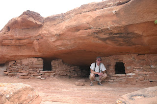
Bill had visited Canyonlands in the past and hiked extensively in the Needles District so we decided to see something new. Island in the Sky is a mesa cut off from the rest of the geography by a forty foot wide land bridge. We managed to get the last of only twelve campsites in the park and had a gorgeous view of the slick rock desert. It was rumored that big horned sheep lived in the area and we were lucky enough to see one from our campsite in the evening. We hiked most of the short trails in the area including one that circled a mesa and let you get up to some ancient native American granaries. We also saw our third snake of the trip, a cute little bull snake. Bill just had to point it out to a bunch of Russian tourist who went crazy trying to get photos of it and asking Bill about whether it was poisonous or not.
Bill hiked the Gooseberry trail. The trail went down 1,400 feet and then along along the canyon floor and of course, back up. In the heat of day with the temps around 85, Bill drank two litres of water and said "...it was a butt kicker hike".
Down into the Great Basin
We left the hot springs for the nearest town of Winemucca Nevada where we checked into an RV campground to do laundry and resupply. We were handed the chamber of commerce brochure and were intrigued to find a full page ad for the Winemucca brothel right next to the church listings...
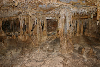
Anyway we dropped in on the Great Basin NP where the ranger informed us that it was the fourth least visited National Park. I had to correct him since he did not have Gates of the Arctic on his list (which gets less that 1000 visitors per year). OK so it's the fifth least visited. There was not problem finding a campsite. Like most places we have gone on this trip, the area had a late winter and most of the trails and some campgrounds were still snowed in. This park has three attractions; 1) a lot of back country for remote backpacking,2) the second highest peak in Nevada (Mt. Wheeler -13063 ft.) and 3) the Lehman Caves (actually only one cave.
This last is not to miss - a beautiful well preserved cave with gorgeous features.
Wednesday, May 14, 2008
Now this is remote!
We left the Steens Mountains and took a 40 mile dirt road to the Hart Mountain Antelope Refuge. We saw some really nice looking antelopes and were the only residents in the Hot Springs campground. There was a spring with a simple wall around it to keep out the animals and one that was completely natural. It was incredibly splendid to take a hot soak surrounded by pristine nature, including snow fields. The place was full of birds and even a bull snake. Bill tossed his fishing line into the tiny creek that you see in the pictures and was getting bites from six inch baby rainbow trout - he didn't keep any. We then stopped at Sheldon Wildlife Refuge in Neveda where we camped at an empty spot in the desert. The next day we drove to Winnemucca where we checked into the High Desert RV Park to do a lot of laundry, get food and diesel and get the Internet.
Birders' Paradise
Continuing to push south into one of the biggest blank areas on the US map we spent three days at the Page Springs campground just outside Malheur Wildlife Reserve. This area has almost 400 species of birds and is a mecca for birders from all over the world. We saw several new ones for us including the huge sandhill crane. The campground was almost empty. Bill rode his mountain bike up the Steens Mountain Loop road ( which was closed to auto traffic due to the snow pack). He got 14 miles and 3,000 feet altitude gain into the Steens before being stopped by the snow. Bill and Debbie hiked a trail up to the top of the mesa where I took several of these pictures. It is impossible to exaggerate the beauty and wealth of wildlife here.
Down into the High Desert!
Ever searching for warmer climes we descended into the southeast corner of Oregon. This area, along with the northwestern part of Nevada must be one of the most remote parts of the US. Traveling here is serious business. You must top off your fuel, water and food tanks every chance that you get - and you do not get many! We were delighted by the rich fossil museum at the John Day Fossil Beds hiked five and a half miles miles into one of the famous mammal fossil areas. We did not realize that this is one of the richest mammalian fossil areas in the world.
Car Crash!
No Debbie wasn't driving, but we came upon this wreck just about two minutes after it occurred. Fortunately the driver was not hurt. This was near a pretty little State Park called Wanapum SP Washington where we camped while we visited the Ginko Petrified Forest SP. We hiked the trails and saw petrified trees and Indian petroglyphs. This was right on the Columbia River right before we ducked back down into Oregon.
Subscribe to:
Posts (Atom)